
Document
Biodiversity Duty Report
Horsham District Council’s Biodiversity Duty Report -
1 January 2024 – 1 January 2026
1. Introduction
All public authorities who operate in England are subject to the strengthened ‘biodiversity duty’ introduced under the Environment Act 2021, which means they must consider what they can do to conserve and enhance biodiversity. This means as a public authority, Horsham District Council must
- consider what can be done to conserve and enhance biodiversity
- agree policies and specific objectives based on this consideration
- act to deliver these policies and achieve the objectives
Government guidance also states that public authorities should consider how they plan to comply with the biodiversity duty in the next reporting period, which is within 5 years of the end date of the current reporting period.
Therefore, the purpose of this document is to report on the policies and actions that Horsham District Council (HDC) have carried out in the last reporting period to comply with the council’s strengthened Biodiversity Duty. HDC have set out the First Consideration, which was published on the council’s Biodiversity webpage in January 2024.
This document will include:
- a summary of the action HDC has taken to comply with the Biodiversity Duty in the stated reporting period, and the progress since the First Consideration
- how HDC plan to comply with the Biodiversity Duty in the next reporting period
- actions that have been undertaken to meet the Biodiversity Net Gain (BNG) obligations
- details of biodiversity net gains resulting, or expected to result, from Biodiversity Gain Plans (BGP) that have been approved
- how HDC plan to meet BNG obligations in the next reporting period
The Environmental Improvement Plan (EIP23), published in January 2023, sets out government plans for significantly improving the natural environment.
By 2030, the government has committed to:
- Halt the decline in species abundance
- Protect 30% of UK land
By 2042, the government has committed to:
- Increase species abundance by at least 10% from 2030, surpassing 2022 levels
- Restore or create at least 500,000 ha of a range of wildlife rich habitats
- Reduce the risk of species extinction
- Restore 75% of our one million hectares of terrestrial and freshwater protected sites to favourable condition, securing their wildlife value for the long term
As such, the action undertaken by public authorities will help contribute to achieving these national goals and targets on biodiversity. Defra intend to include references from public authority biodiversity duty reports to inform their 5-yearly reviews of the Environment Improvement Plan.
2. Horsham District Biodiversity
Biodiversity is the variety of all life on earth, including animals, plants, fungi and microorganisms such as bacteria. It can be measured on various levels, for example by looking at species and habitat diversity, genetic diversity and ecosystem diversity.
Across Horsham District which comprises a land area of approximately 53,000 hectares, a variety of habitats can be found, ranging from the vast irreplaceable ancient woodlands in the north, to the priority calcareous grassland and chalk rivers to the south. Two main rivers flow through the district, the River Adur and River Arun, surrounded by floodplains and coastal grazing marsh. The district also supports multiple pockets of priority woodland and several areas of traditional orchards, parkland and heathland.
The district is also home to many notable species, including the nationally rare Bechstein and Barbastelle bats, hazel dormouse, rush wainscot moth, nightingales, and tree sparrows.
Numerous designated sites and landscapes are found in the district, including the Arun Valley (SAC, SPA, Ramsar), High Weald National Landscape, South Downs National Park, Warnham Local Nature Reserve, alongside 23 Sites of Special Scientific Interest and 71 Local Wildlife Sites. In the centre of the district lies the Knepp Estate, a large rewilding project that has gained national recognition for its conservation efforts to re-establish rare species populations, including but not limited to beavers, white stork, turtle dove, and purple emperor butterfly.
Multiple projects are underway across the district with aims to restore and enhance biodiversity, both on a local and landscape scale. For example, the Weald to Waves project aims to create a 100m long wildlife corridor connecting coastal habitats such as kelp forests to the Ashdown Forest via three river routes, and the Adur River Recovery project aims to re-naturalise channels and floodplains whilst supporting sustainable farming.
Horsham District Council funds the Wilder Horsham District project, in partnership with Sussex Wildlife Trust. The project works with farmers, landowners and community groups to enhance sites for wildlife through advice, a small grants scheme and volunteer powered practical tasks. It works beyond the scope of the individual land holdings and has developed a Nature Recovery Network map to promote connectivity of habitats across the district. In addition, upon the announcement of the Biodiversity Net Gain requirement for developments seeking planning permission, multiple parcels of land have been designated as areas to deliver habitat improvements to assist with the emerging market.
Biodiversity is generally in decline across the nation, with the State of Nature Report (2023) reporting 1 in 6 UK species at risk of extinction, with a 55% reduction in farm birds since 1970 and more than 50% of UK plant species having decreased in their distribution. With relevance to the habitats and species found in West Sussex, notable non-government organisations report chalk grassland has reduced by 80%, heathland has reduced by 85%, hundreds of miles of hedgerow have been lost, corn buntings have witnessed a 82% decline since the 1960s and are considered lost in neighbouring county Surrey, water voles have declined by 90% in the last 30 years, and between 30-75% of hedgehogs have been lost since the 1950s. These statistics, alongside many more, have resulted in the UK being one of the more nature depleted countries in the world. As such, conservation efforts are important, now more so than ever.
The actions undertaken by Horsham District Council have the potential to both positively and negatively impact biodiversity, for example in relation to how land and estates are managed, planning and development decisions, and day-to-day operations. The following sections of this report detail the council’s policies and actions following the First Consideration published in January 2024, and the forecast measures to improve biodiversity across the district.
3. Policies, Objectives and Actions
The Council’s Biodiversity Duty First Consideration report, published January 2024, made clear that all public authorities have internal policies and processes for staff and facilities that could affect biodiversity. It advised that HDC will consider how its policies may affect biodiversity and seek to review and improve these for better outcomes.
Government guidance provides examples of the policies and strategies that could be reviewed, these are as follows:
- Transport – support sustainable travel to reduce carbon emissions and improve air quality
- Waste – review waste management and recycling processes to reduce water pollution and air pollution from waste transport and landfill
- Water – improve water efficiency to reduce the effect water abstraction can have on sensitive habitats and species
- Procurement – buy sustainable materials and supplies to reduce the demand on natural resources
- Light – make sure the design of artificial lighting minimises effects on nature
- Human resources – promote and educate staff on biodiversity issues
- Estate – improve the management of your land for biodiversity
- Sustainability – make sure biodiversity forms a part of sustainability considerations
The following provides an update on the actions in place, undertaken and proposed, either alone or in partnership with others, that benefit biodiversity since the publication of the Biodiversity Duty First Consideration report.
4. Corporate Actions
Council Plan
Current Position:
The Council Plan 2023-2027 remains in place. One of its themes is “inspiring greener futures” and identifies methods to reduce carbon emissions and use of natural resources to achieve Net Zero by 2050 as key priorities. It makes clear the Council aims to be a net zero council by 2030 and a net zero district by 2050. It seeks for the district to be held in high regard for best practice in rewilding, regenerative farming and recycling. The priorities include creating nature diverse places for people to live in, investigating the benefits and opportunities for Biodiversity Net Gain and carbon credits for HDC and landowners within the district, and supporting methods towards achieving net zero by 2050 by encouraging switching to greener technologies, and cutting carbon emissions and water usage. Many actions are listed which the Council continues to try to fulfil and keeps updated via the Annual Plan (see below).
Regard has also been given to sustainable procurement which includes taking biodiversity into account in relevant procurement processes, to reduce the demand on natural resources.
Several actions are of particular importance in respect of conserving and enhancing biodiversity, and these are:
- Annual Plan 2024 – 2025: Establish wildlife corridors across the district by adjusting mowing regime.
- Annual Plan (2023 – 2024) Support development of LNRS.
- Consider next steps for Wilder Horsham District Initiative
Further work/actions/ next steps:
The Council Plan will be reviewed to set out the Council’s shared vision for Horsham District and what the Council wants to achieve post 2027. Regard should be given to the Climate Action Strategy.
Method of monitoring:
Corporate monitoring and reporting Key Performance Indicators (KPIs).
Annual Plan
Current Position:
The Annual Plan sets out the key projects and investments for the year ahead and helps ensure HDC’s work reflects what residents and businesses value the most.
Public consultation on the draft Annual Plan 2026-2027 was undertaken between 24th November to 8th December 2025. It is set out under four themes which align with those in the Council Plan 2023-2027 and includes “inspiring greener futures”. Under this heading the draft Annual Plan sets out 5 measures with some suggested actions which are:
Deliver a Local Plan or other relevant planning guidance documents which sets higher environmental standards including net zero building, green gaps and addressing water neutrality.
- Undertake a review of the Conservation Areas of Crabtree, Rudgwick, and Thakeham, and produce a Conservation Area Appraisal and Management Plan document for these areas.
Show the way to net zero through engagement with our community and our emerging Climate Action Strategy.
- Review works required to achieve an EPC C rating in all let residential and commercial properties.
- Roll out a programme of carbon literacy training for community groups and Parish/Neighbourhood Councils.
Create nature diverse places for people to live in.
- Review and document the impact of the Wilder Horsham District Initiative, with a view to ensure its longer-term retention as an effective delivery mechanism for the Local Nature Recovery Strategy.
- Produce and document the impact of the Wilder Horsham District Initiative, with a view to ensure its longer-term retention as an effective delivery mechanism for the Local Nature Recovery Strategy.
- Investigate options for Roffey Recreational Ground (Fields in Trust).
- Develop a Plan to make the Council’s land at Cedar’s Farm an open access recreation site, and to transfer to Billingshurst Parish Council if that is supported by the Parish.
Help businesses and residents to waste less and recycle more.
- Complete the introduction of the domestic food waste collection service by the end of April 2026.
- Develop a project plan for the efficient recycling of soft plastic.
Create safer routes for cycling and walking.
- Work with West Sussex County Council, Parish and Neighbourhood Councils to develop proposals to expand Horsham District’s active travel routes including cycle network.
- Develop a Horsham District cycling and walking strategy.
Further work/actions/ next steps:
At the time of writing, the Annual Plan is to be finalised after reviewing the responses to the public consultation and measures to be taken forward as actions for the year.
Method of monitoring:
Corporate monitoring and reporting Key Performance Indicators (KPIs).
5. Report Templates
Current Position:
The template for reports, including Cabinet and Committee reports, requires inclusion of information in respect of “Environmental Implications”. This is to cover any impact on the environment such as on the use of natural resources (for example energy, water, raw materials); quality of environment (contribution to safe and supportive environments for living, recreation and working); biodiversity (protection and improvement of wildlife and habitats); and waste and pollution (effects on air, land and water from waste and emissions.
Further work/actions/ next steps:
This will be kept under review to ensure environmental implications are appropriately considered in reports and Council decisions.
Method of monitoring: N/A
6. Indirect Action and Behaviour Change
Current Position:
- Implementing nature recovery principles through the organisational resilience strand of Wilder Horsham District work.
- Continuing to deliver the carbon reduction action plan that indirectly conserves and protects biodiversity like retrofitting buildings, electrifying fleet vehicles and delivering carbon literacy. Includes introducing biodiversity and nature e-learning modules for HDC staff.
Further work/actions/ next steps:
Wilder Horsham District to run workshops with HDC Property Team to determine actions to embed nature recovery principles as part of their job role.
Method of monitoring:
Quarterly and annual reporting. Feedback and action plans from workshops.
7. Waste
Cleansing Vehicles and Refuse Collection Vehicles Fleet - Fuel
Current Position:
The Council is working towards reducing its carbon footprint and District wide carbon emissions and has set a target to aspire for it’s direct emission to become net zero by 2030. The annual carbon audits for the Council show that the in 2023/24 the Council has decreased its direct emissions by 64% since its baseline report in 2019/20.
This is in part due to the use of Hydrogenated Vegetable Oil (HVO) in the Council’s fleet of vehicles, including the larger Refuse Collection Vehicles (RCVs) which currently would not have the capacity to complete rounds if electric. The use of HVO instead of diesel has resulted in around 90% fewer emissions. The council now has on it’s fleet 14 electric vehicles and 6 hybrid vehicles.
This includes four of its Litter and Cleansing Teams vehicles where a further three vehicles will be electrified in August 2026. The changes in the Council’s fleet has resulted in a reduction of 1,197 tonnes of CO2 emissions (tCO2e) from 1214tCO2e to 17tCO2e. This helps to have a positive impact on climate change and therefore the conservation and enhancement of biodiversity. The Council is continuing to look at replacing all vehicles with emission free models by the end of 2030.
Further work/actions/ next steps:
The Council continues to follow its Carbon Reduction Plan to meet sustainability targets and completing demos to explore potential technology to electrify refuse vehicles.
Method of monitoring:
Project team meetings every 6 weeks to evaluate progress against milestones as part of the 25-30 action plan. Annual carbon reporting tracks year-on-year changes in fleet emissions and progress reports to the Senior Leadership Team (SLT) and Members at the end of fiscal year.
Food Waste
Current Position:
The Government has announced new legislation requiring all councils in England to collect food waste starting from March 2026. The Council is working closely with the West Sussex Waste Partnership to help deliver these changes, which will also help it to improve its recycling rates.
More than 40% of the rubbish, by weight, in an average Horsham District bin is food waste. The Council has a municipal waste target to recycle 60% of all waste by 2030 and by introducing food waste, is expected to meet this target in 2026/27.
Plate scrapings, tea bags, banana peels: no matter how little food is wasted, it’s really important that it is recycled. A food recycling bin will always be emptied no matter how little it contains.
WRAP research shows that separate food waste collections are strongly associated with lower total food waste, because when food waste is separated from general waste, householders realise the amount they are throwing away and begin to change their behaviour - and may save household food bills in the process! The Council is therefore looking to separate food waste from the general waste. Collections are due to start from March 2026.
Once collected in the specially designed smaller collection vehicles, food waste from homes across Horsham District will be transported to the Horsham Anaerobic Digestion Plant, operated on behalf of West Sussex County Council.
At the plant, the waste will undergo anaerobic digestion, a process that converts waste into biofertiliser and renewable energy. The biofertiliser will be supplied to local farmers for use on their fields, while the energy generated will power the plant itself, with any surplus energy exported to the national grid to provide power for homes. The Council is therefore taking into account the need to conserve and enhance biodiversity when it roles out the food waste collection service.
Further work/actions/ next steps:
The systems and processes put in place to deliver the food waste collection service will be kept under review.
Method of monitoring:
Waste monitoring will be ongoing to check progress on targets set.
8. Procurement
The Sustainable Procurement Charter
Current Position:
The Council continues to follow the principles of The Sustainable Procurement Charter. Particularly relevant is the priority to ensure ‘A cared for environment by applying good environmental business practices’ which outlines various charter commitments that conserve and enhance biodiversity:
- 4B - Support the enhancement and conservation of local biodiversity and green/public spaces.
’Reasonable effort’ is demanded from suppliers for services valued between £50,000 and £250,000 and for works valuing between £100,000 and 2,000,000. Whereas the commitment is mandatory when supplying services over £250,000 and works over £2,000,000.
- 4C - Adhere to ethical and responsible sourcing practices (All paper or timber products purchased are required to be recycled or sourced from sustainable forests, with a clear chain of custody).
This is mandatory for all suppliers.
- 4D - Reduce the use of natural resources and support the principles of a circular economy.
’Reasonable effort’ is demanded from suppliers for services valued between £50,000 and £250,000 and for works valuing between £100,000 and 2,000,000. Whereas the commitment is mandatory when supplying services, goods and works above these thresholds.
- 4E - Avoid the creation of waste (including reducing or eliminating the use of single use plastics) and promote reusing and recycling.
Mandatory for all procurement apart from services below £50,000, which asks for ‘reasonable efforts’.
Suppliers are also expected to support the Council’s Wilder Horsham District programme by enhancing habitats (such as restoring or planting hedgerows) or inspiring the local community to appreciate local wildlife.
Further work/actions/ next steps:
Engaging with the largest suppliers and supporting them with their sustainability action plans through free access to the Climate Essentials for Supply Chain online management tool. Supporting the top fifty suppliers through to April 2027
Method of monitoring:
Monitoring agreements through contract managers, annual reports and action plans from suppliers.
9. Parks & Countryside Estates
Greenspace Strategy
Current Position:
The Greenspace Strategy was published in June 2024 and covers the period between 2024 to 2029. It sets the approach to the management of the Council’s own landholdings (approximately 400ha [988acres], over 200 sites) and sets out the standards the Council aspires to for its parks and open spaces in Horsham District. It provides a focus for the management and improvement of space and focuses on publicly accessible areas that the Council owns.
"To ensure that Horsham District Council’s Greenspaces are protected for future generations and managed to provide good quality public greenspace for amenity and leisure use, as well as maximising its value for biodiversity, nature recovery, climate mitigation and adaptation."
It sets out how the Council plans to achieve five core aims:
- Protect, maintain, and enhance existing greenspaces to a good standard.
- Greenspaces should have significant value for public health and wellbeing and provide a range of opportunities for amenity and leisure use.
- Sites will be managed sustainably and seek to enhance biodiversity, nature recovery, climate resilience including both drought and water management.
- New greenspace and facilities should meet the principles for amenity and biodiversity value.
- Value, support and encourage volunteer groups’ input into the Council’s greenspaces.
Further work/actions/ next steps:
Continue to apply the aims set out in the Strategy to the Council’s own landholdings. Review the strategy so that an update sets out the approach post 2029.
Method of monitoring:
Publication of reports, biological survey data and progress towards identified targets.
For further information on projects and actions relating to parks and countryside please also see the separate section titled ‘HDC Land’.
10. Planning
Preparation of the new HDC Local Plan/emerging Local Plan (eLP)
Current Position:
The Council submitted the Horsham District Local Plan 2023-2040/emerging Local Plan (eLP) to the Secretary of State for examination in July 2024. Due to differences of opinion relating to the Duty to Cooperate the eLP remains at the examination stage. At the time of writing a procedural/exploratory meeting between the Council and the Inspector could take place in February 2026 to explore the implications for the Examination of the Government’s intent to abolish the Duty to Cooperate.
The eLP sets out policies and proposals intended to guide development in the district up to 2040, excluding the South Downs National Park because this forms a separate planning authority area. Its policies require the conservation and enhancement of biodiversity and Strategic Policy 17 ‘Green Infrastructure and Biodiversity’ sets a requirement for qualifying development to meet 12% BNG and promotes nature recovery and enhancement.
Strategic Policy 11 ‘Environmental Protection’ expects development to minimise exposure to, and the emission of, pollutants including noise, odour, vibration, air and light pollutions arising from all stages of development in order to protect human health and the natural environment. This includes regard to the South Downs International Dark Sky Reserve designation. Strategic Policy 12 ‘Air Quality’ recognises the direct effects air quality has on public health, natural habitats and biodiversity, and sets out a number of requirements to be met by development.
The eLP also contains Strategic Policy 9 ‘Water Neutrality’ 9 and HDC contributed towards the Sussex North Water Certification Scheme (SNWCS) (formerly called Sussex North Water Offsetting Scheme [SNOWS]) to facilitate developments to meet the requirements of Policy 9 and compliance with the Water Neutrality Position Statement issued by Natural England in September 2021. Evidence gathered indicates water efficiency measures could reduce use to 85 litres per person per day, as proposed for offsetting schemes. The emerging Local Plan therefore sets the Building Regulations optional requirement for tighter water efficiency in new residential development of no more than 110 litres of mains supplied water per person per day (or tighter should national standards be introduced over the plan period). The Water Neutrality Position Statement was withdrawn by Natural England on 31 October 2025 which will have implications for Strategic Policy 9.
Further work/actions/ next steps:
If the eLP is allowed to progress to full Hearings, HDC will defend the 12% BNG requirement and seek to justify retaining the tighter water efficiency standard of 110 litres per person per day (or lower if the optional tighter standard is reduced by Government) in new residential development in eLP Strategic Policy 9.
Method of monitoring:
Authority Monitoring Report (published annually) and next Biodiversity Report.
Green Infrastructure Strategy
Current Position:
The 2014 strategy was reviewed, and an updated Green Infrastructure Strategy was published in January 2024 to sit alongside the background evidence to the Local Plan. This has helped to inform the County Council’s Local Nature Recovery Strategy (LNRS).
Further work/actions/ next steps:
No further action at this stage but will be kept under review to ensure it aligns with the Local Nature Recovery Strategy which West Sussex County Council aims to publish in March 2026.
Method of monitoring:
N/A
Biodiversity and Green Infrastructure Planning Advice Note (PAN)
Current Position:
This PAN was published in October 2022 to provide interim guidance prior to the mandatory 10% BNG coming into force in 2024.
Further work/actions/ next steps:
This has largely been superseded by the BNG Regulations and Guidance published in 2024. Other aspects will be superseded by the emerging Local Plan if progressed to adoption. If no longer relevant the PAN will be withdrawn.
Method of monitoring:
N/A
Determination of Planning Applications in Accordance with Current Wildlife Legislation and Policy.
Current Position:
An Ecology Officer has been employed to assist with BNG requirements and also ecology consultations relating to strategic sites, such as reviewing Environmental Impact Assessments (EIAs) and Ecology reports. This also includes consideration to the need to enhance and protect SSSI’s and to comply with policy and legislation to conserve protected sites i.e., SAC, SPA, NNR, LNR, LWS, and Ramsar sites.
The Mens SAC and Ebernoe Common SAC has functionally linked land that covers much of the western half of the District (Bat Sustenance Zone). Continued review of planning applications, largely undertaken by external Consultant under a service level agreement, that includes assessment of all impacts if the site lies within 6.5km from SAC, or significant impacts or severance to flightlines if within 12km.
Further work/actions/ next steps:
Continue to review planning applications in line with current wildlife legislation and relevant Local Plan policy, and professional best practice (and any subsequent updates).
Method of monitoring:
Authority Monitoring Report and ongoing monitoring of planning applications by external stakeholders, including Natural England, that hold the Council to account.
Great Crested Newt District Licencing Scheme
Current Position:
Great Crested Newts (GCN) and their habitats are legally protected in the UK and must be considered as part of the planning process. Applicants may need a licence to carry out development work where the species may be present, if it can’t be demonstrated that there is no risk of impact.
The Council has been issued with a District Licence which is regulated by Natural England, which provides an alternative licensing route to the traditional European Protected Species Mitigation Licence (EPSML). The licence is operated by NatureSpace on behalf of the Council. The first licence was issued in May 2023 and is in the process of being renewed.
The Council consults the dedicated newt officer at NatureSpace on all applications where it is considered there may be an impact on GCN or their habitats. Comments from the newt officer will then be considered as part of the planning assessment. The mitigation hierarchy is fully integrated into the newt officer assessments, including consideration of whether impacts to newt populations would be so severe as to warrant site avoidance (in whole or in part). Tailored mitigation requirements are applied to high-risk sites based on the final-scale considerations of individual developments.
If choosing to pursue the district licence route, an applicant must apply for this before or during, not after, the planning process. The District Licence is designed to allow developers to pay for high-quality, strategically located off-site compensation within West Sussex that benefit GCN populations, whilst allowing construction to proceed on-site with fewer mitigation requirements.
With the funds received to date (May 2023 – December 2025), NatureSpace have secured 70.2ha of terrestrial habitat compensation within Horsham District, including 17 created/restored ponds., exceeding the compensation requirements for the area (5.064ha of terrestrial habitat and 0.32 number of ponds). Compensation sites have been created throughout Horsham within land owned by Knepp Castle Estate and private landowners (Figure 1).
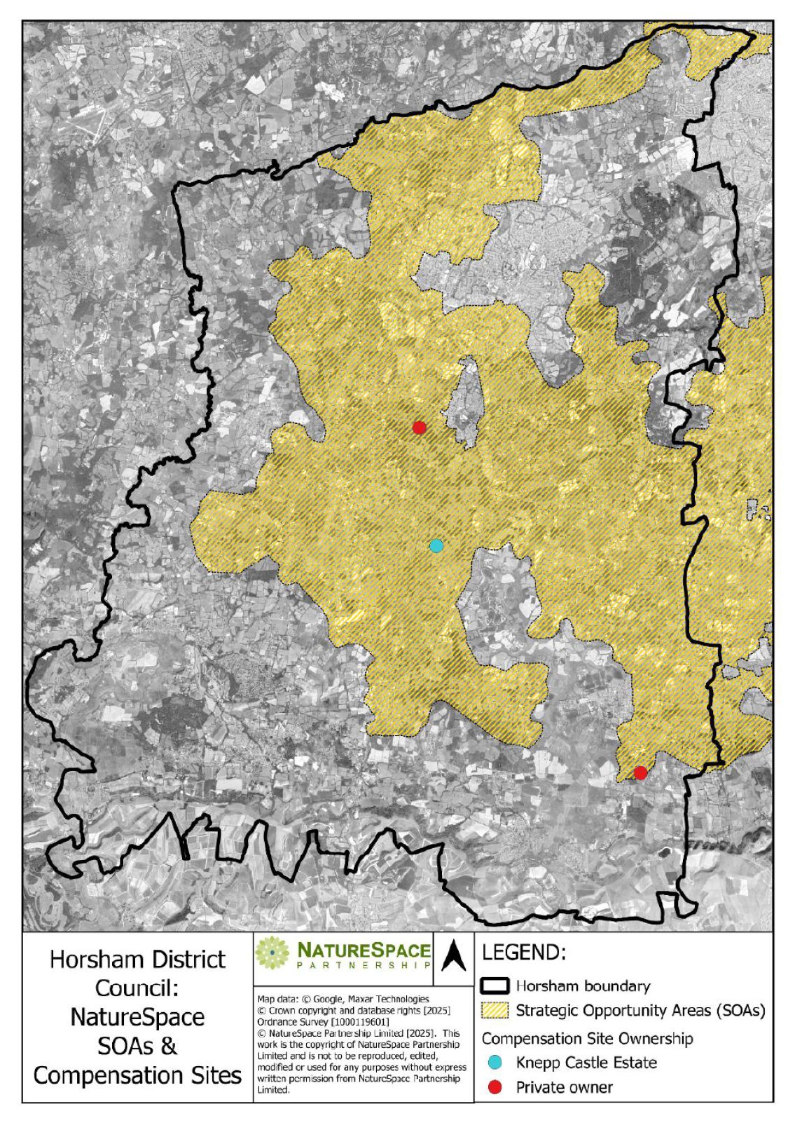
Figure 1 A map showing strategic opportunity areas and compensation sites within Horsham District (provided by NatureSpace, Dec 2025)
Further work/actions/ next steps:
Assist with the renewal of the licence operated by NatureSpace on behalf of the Council, and apply conditions in accordance with licence requirements, as appropriate.
Method of monitoring:
NatureSpace provide updates in bi-bi-monthly meetings. All created and restored ponds and habitats are monitored and managed for a minimum 25-year period.
11. Transport
Active Travel
Current Position:
HDC has created a new role titled “Active Travel Co-ordinator” with the aim of having someone in post by Spring 2026. They will review planning applications and seek to ensure the best outcomes in respect of active travel.
Further work/actions/ next steps:
Recruit to post in 2026.
Method of monitoring:
N/A
12. Environmental Partnership Projects
Wilder Horsham District
Current Position:
This was set up as a five-year partnership between Horsham District Council and the Sussex Wildlife Trust (it commenced in 2020). It was reviewed in 2024/25 to learn from what had been delivered to date. On the 25 September 2024 the Council approved the continuation of, and funding for, the initiative until 31 March 2028 (a further 3 years). A new Collaboration Agreement was put in place which included updated deliverables for the project.
This significant project works closely with local communities and landowners to reverse the decline in wildlife by creating and connecting habitats to deliver a Nature Recovery Network for the Horsham District.
The Council pays for two full time landowner advisers and one part-time project support officer. These are employed by the Trust.
The objectives of the project are: -
- Help wildlife thrive across the Horsham District.
- Create networks of land that are protected and enhanced for wildlife, to allow habitats to expand and for species populations to increase which will ensure that they are resilient to change.
- Increase awareness of actions that communities can take to improve their local natural environment and the benefits that wildlife provides.
- Maximise the opportunities that protecting and enhancing wildlife brings for climate change mitigation and adaptation.
An aspirational Nature Recovery Network (NRN) has been mapped for the district Horsham District Nature Recovery Network | Sussex Wildlife Trust. This helps direct the work of the project. Prior to the Local Nature Recovery Strategy (LNRS) this map will be used to help advise on potential off -site BNG sites.
The project supports bespoke and, largely, in-person advice to landowners and farmers on changes they can make to land management for the benefit of wildlife. At the time of writing, WHD has advised 160 different landowners over the last six years, with the aim of increasing habitat connectivity across and between 10,600ha of land. In 2025-26, WHD made 51 advice visits to landowners, of which 20 were new sites and 31 were follow-ups to existing partners. This is currently exceeding the hard target of 20 landowner visits per year.
The WHD Annual Report 2024-25 also identified that the project has influenced approximately 890ha of land, which has involved putting 62ha of land into naturalistic grazing, building 2 ponds and installing 12 leaky dams, planting 440 trees and 157 orchard trees, and clearing 13 sites of non-native invasive species.
The project also gives advice to community groups, as well as Parish and Neighbourhood Councils on the role they can play in enhancing biodiversity. This can either be on their own land or by working with their local communities, such as creating pollinator highways. Two workshops were held for Parish and Neighbourhood Councils with practical advice on what actions they can take.
The landowner and community strands are supported by a grant scheme, known as the Nature Recovery Award. This provides grants of up to £5k towards projects that enhance biodiversity and contribute to the delivery of a nature recovery network. In 2025-26, WHD provided seven nature recovery grants worth £22,000.
Volunteer work parties, run by the project team, can also provide practical support for landowners, such as hedge laying and clearing invasive species. In 2025-26, 20 tasks have been completed with over 4,500 volunteer hours contributed.
As part of this project the Council is seeking to ensure that the principles of the project are embedded throughout the organisation. Part of this has been through staff and Member talks/presentations, as well as work with key departments, such as planning and parks and countryside. The latter team already manages its key countryside sites to enhance biodiversity. However, management regimes across the estate have been reviewed and updated where possible. Council land has been mapped alongside the NRN. This shows opportunities to work with landowners neighbouring Council land which it could work with to start developing local NRN’s.
The final part of the project is to promote biodiversity enhancement to the wider community. This is through talks, press releases and articles in the Council magazine. These also include actions that individuals can take to enhance biodiversity in their own gardens, however small these maybe.
Further work/actions/ next steps:
Review the project to determine how it may continue after Local Government Re-organisation and what form it will take going forward, learning from what has been delivered to date. Critically its proven track record of engagement and delivery makes it an important effective delivery mechanism for the LNRS.
Ongoing contact with landowners, community groups and Parish / Neighbourhood Councils.
Use of social media, and Council, as well as the Wildlife Trust publications to promote the project, and what it is achieving.
Method of monitoring:
The project is overseen by a Steering Group consisting of representation from the Council and the Trust. This monitors progress against performance indicators and deliverables in the contract.
River Adur Recovery Project
Current Position:
HDC is a partner in this pilot Landscape Recovery project (a strand under the Environmental Land Management Scheme). The first two years of DEFRA funding was for the development phase. The funding was mostly to complete studies across 27 landholdings to understand land management changes that could be implemented to revitalise and restore the river and its floodplain.
Since the Biodiversity Duty First Consideration Report the landowners will have received their reports on changes they can make to their land. Workshops with the landowners have been held to develop a shared vision of the changes that could be made along the river. (The following link provides further information: https://www.adur-river-recovery.org.)
Further work/actions/ next steps:
A series of community events will be used to explain the project and what changes may take place to the river.
Method of monitoring:
Reports from Adur Recovery Project as appropriate.
Weald to Waves
Current Position:
HDC is a partner is this project that is led by the Knepp Wildlife Foundation to create a nature recovery corridor. The aspiration is for this to extend from the Sussex coast up the River Arun and the River Adur (as well as the River Ouse in East Sussex) via St Leonards Forest to Ashdown Forest. The corridor covers 20,000ha and is over 100 miles in length. Much of this lies within the Horsham District. (The following link provides further information: https://www.wealdtowaves.co.uk/.)
Further work/actions/ next steps:
Continue to assist the project leads including with obtaining pledges from landowners and individuals (gardens) to be part of the wildlife corridor.
Method of monitoring:
Reports from Weald to Wave Project as appropriate.
Arun and Western Streams Catchment Partnership
Current Position:
HDC sits on the Partnership board, which is led by the Western Sussex Rivers Trust (WSRT) Their vision is for a “healthy river system where all interested sectors, groups or individuals may contribute towards restoring the natural environment to benefit people and wildlife now and in the future.”
Further work/actions/ next steps:
Continue to attend Board meetings and support future projects as appropriate.
Method of monitoring:
Reports from Catchment Partnership as appropriate.
Sussex North Water Supply Zone – Water Neutrality Authority Partnership Working
Current Position:
Following receipt on the 14 September 2021 of a Water Neutrality Position Statement, from Natural England, Horsham District Council worked in partnership with the other local authorities affected (Horsham, Crawley, Chichester and South Downs National Park) and key stakeholders including Southern Water, Environment Agency, Natural England and respective personnel from Government Departments. The Natural England position was that it could not be concluded that the existing abstraction within the Sussex North Water Supply Zone was not having an impact on the Arun Valley Special Area of Conservation (SAC). It advised that development within this zone must not add to this impact.
Development was therefore to be water neutral. HDC was a key instigator of a joint approach to help development to come forward. Two new posts were created, based at HDC, that worked across all the local authorities affected (Water Neutrality Project Manager and then the Water Neutrality Officer). The Water Neutrality Position Statement was withdrawn by Natural England on 31 October 2025 which led to the removal of the Water Neutrality Project Manager post in December 2025.
Further work/actions/ next steps:
Whilst the Position Statement has been withdrawn, it remains the case that Horsham District Council remains the competent authority under the Habitats Regulations, and therefore must be assured that the mitigation will be effective in practice and suitably secured. Given the necessary licence change has not yet taken place (the withdrawal statement refers to March 2026), the Council cannot be certain that the issue is yet fully resolved.
For individual applications, the Council will use the 2024/25 water efficiency savings made by Southern Water to allow all development to move forward as water neutral from 1st November 2025. These savings were previously to be used by the Sussex North Water Certification Scheme (SNWCS), and amount to some 3,240,000 litres per day. SNWCS, for the avoidance of doubt, will no longer be launched.
To ensure continued compliance with the Habitats Regulations until the licence change has taken effect, please note that officers will continue to undertake an Appropriate Assessment of planning proposals as part of their overall considerations.
Existing planning permissions with conditions and s106 obligations requiring compliance with bespoke water neutrality mitigation, the Council will consider applications under s.73 of the Town and Country Planning Act to remove those conditions, and any associated applications to vary or discharge any relevant s106 obligations. If the permission was for new dwellings a condition requiring compliance with the Building Regulations Part G Optional Technical Standard will be applied (as it was prior to the 2021 Position Statement).
Method of monitoring:
Planning approvals and their predicted water usage will be monitored, by the Water Neutrality Officer, across all authorities within the Sussex North Water Supply Zone to ensure the threshold of 3,240,000 litres per day is not exceeded prior to the necessary licence change.
Gatwick Greenspace Partnership (GGP)
Current Position:
HDC is a funding partner of this community wildlife project, working across organisational boundaries in north Sussex and south Surrey. HDC sits on the steering group and benefits from practical habitat management via the GGP volunteers. Schools within the district receive support on advice on nature connection and upkeep of grounds.
Further work/actions/ next steps:
Continue to provide financial support and help to transition organisation through local government reorganisation
Method of monitoring:
Via steering group reports and minutes.
Local Wildlife Sites Initiative
Current Position:
HDC has subscribed to the Sussex Local Wildlife Sites Initiative (LWSI) operated by the Sussex Biodiversity Record Centre since 2018. This initiative operates across the whole of Sussex helping to ensure a consistent approach to site designation and review of sites in accordance with Defra guidance. The initiative helps to ensure Local Wildlife Sites are accurately represented in Development Plans and receive due consideration in the planning and development process. It also helps in the provision of targeted management advice. An officer from Horsham District Council attends the LWSI Steering Group which meet twice a year or as appropriate.
Further work/actions/ next steps:
Seek to ensure LWS continue to be reviewed by subscribing to this cost-effective joint initiative and support the designation of new sites especially those integral to the Local Nature Recovery Strategy (LNRS) which should be finalised in the Spring of 2026.
Method of monitoring:
Via steering group reports and minutes.
Requirements and Obligations
There are certain environmental requirements and obligations in place in respect of Development Plans and decisions. Government guidance seeks to ensure the Council, as a local planning authority, considers its biodiversity duty when complying with the requirements for:
These are covered below respectively.
Habitat Regulations Assessments
The objective of these assessments is to identify any aspects of a development plan (including Local Plan and Neighbourhood Plan) that would cause an adverse effect on the integrity of European sites either alone or in combination with other plans and projects. They must comply with the Habitats and Species Regulations 2017 (as amended).
Development Plan
Horsham District planning Framework
The Horsham District Planning Framework (HDPF) was adopted in 2015 so its Habitat Regulations Assessment Appraisal is not of relevance to this Biodiversity Duty Report.
Emerging Local Plan
The Council appointed AECOM to undertake a Habitats Regulations Assessment (HRA) of its Regulation 19 Local Plan. The assessment included a formal screening for any Likely Significant Effects (either alone or in combination with other plans or projects). This is explained in Chapter 2 of the HRA which also outlines the methodology of the assessment. The screening report was sent to Natural England, with further engagement with Natural England following different stages of the Plan’s preparation, particularly with respect to water neutrality.
Chapter 3 of the HRA assesses the ‘Relevant Impact Pathways’ on the European sites. Where these effects cannot be excluded, assessing them in more detail through an Appropriate Assessment (AA) is required to ascertain that an adverse effect on the integrity of the site can be ruled out and this is assessed in detail throughout Chapter 4 and Chapter 5 of the HRA. Where an adverse effect on a European site cannot be ruled out, and no alternative solutions can be identified, then the project/plan can only then proceed if there are imperative reasons of over-riding public interest (‘IROPI’) and if the necessary compensatory measures can be secured. Chapter 7 concludes that suitable mitigation has been identified for all possible significant effects (most notable are those relating to the Arun Valley Sites and water abstraction, and to The Mens SAC and air quality), therefore the IROPI test has not been applied.
Existing water abstraction within the Sussex North Water Supply Zone and impact on the Arun Valley Special Area of Conservation (SAC) and water neutrality has been covered in detail in other sections of this report so is not covered further here (please see “Preparation of the new HDC Local Plan/emerging Local Plan” and “Sussex North Water Supply Zone – Water Neutrality Authority Partnership Working”).
Following representations made by Natural England at Regulation 19 relating to a potential impact from local plans on atmospheric ammonia levels affecting The Mens Special Area of Conservation (SAC), further assessment of air quality was undertaken in September 2024 and published as an addendum to the Local Plan HRA Habitats Regulations Assessment Air Quality Addendum. This examines in detail the emissions of nitrogen oxides (NOx) and ammonia (NH3) from traffic on the A272 past The Mens SAC over the plan period. This work supersedes the air quality assessment reported in paragraphs 6.51 to 6.75 of the main HRA. The Air Quality Addendum is accompanied by the Habitat Regulations Assessment Air Quality Mitigation Strategy, which addresses the Natural England representation. It should be noted with the exception of Air Quality the conclusions of the HRA and proposed mitigations have been agreed, as reflected in the Natural England Statement of Common Ground, between the Council and Natural England.
An air quality policy has been worked up in conjunction with Natural England and Chichester District Council, as its Local Plan show similar in combination impacts. Should the emerging Local Plan proceed it is anticipated the air quality policy will form a main modification and consulted upon in 2026. If the Local Plan, with the air quality policy, is adopted then mitigation and monitoring will be undertaken in accordance with policy.
There is the expectation for the Plan to be reviewed well before 2032 and acknowledgement from Natural England that there would be little risk to ammonia impact to the Mens SAC. Both Horsham District and Chichester District will continue to work closely with Natural England on this matter.
Neighbourhood Plans
A neighbourhood plan proposal must provide sufficient information to enable a competent authority to undertake an initial check to see if the plan, alone or with other projects, might significantly affect a European site. Horsham District Council is the competent authority under the Conservation of Habitats and Species Regulations 2017 and needs to ensure that Neighbourhood Plans have been assessed through the Habitats Regulations process. It should be noted the Local Plan (HDPF) has already been subject to SA/SEA and HRA assessment. In some circumstances the findings of these existing assessments may be sufficient to cover the effects of a Neighbourhood Plan, and a judgement on this will form part of the screening exercise. This will depend on the content and policies contained within the Neighbourhood Plan. As part of the Duty to Support, HDC have supported and advised the 24 Qualifying Bodies on matters relating to HRA.
The Council has assisted and advised all local groups with a basic initial screening early in Neighbourhood Plan process to assess whether it is likely a HRA will be required. This initial screening will mainly be assessing whether any Internationally designated site could be impacted by the proposals within the Neighbourhood Plan.
From this screening process, 14 Neighbourhood Plans went on to undertake the Appropriate Assessment stage which looked to address the adverse impact of proposals, devise appropriate avoidance and mitigation strategies to ensure the plan was compliant with the habitat regulations.
The different stages are outlined below:
- Screening: An initial check to see if the draft neighbourhood plan, alone or with other plans, could have a "Likely Significant Effect" (LSE) on a European site (e.g., Special Protection Areas, Special Areas of Conservation).
- Appropriate Assessment (AA): If LSEs are identified during screening, a full AA is required to assess the effects in detail, determining if the integrity of the site would be adversely affected. This requires the assessment of the impact of the proposal on the site's conservation objectives in detail, considering avoidance and mitigation strategies to rule out any adverse effects. Consultation with Natural England must be undertaken. Taking account of mitigation, the AA will determine whether or not there are residual adverse effects on the integrity of the designated site. If residual adverse effects are ruled out, then the plan can proceed. If not, then the Competent Authority should not allow the plan to proceed, subject to whether a derogation applies.
- Derogation (if needed): If adverse effects can't be ruled out in the AA, the plan can only proceed if there are no alternatives, it's for imperative reasons of overriding public interest (IROPI), and compensation measures are secured.
Development Management
Under the Habitats Regulations in England and Wales the potential impact that a development could have on European designated sites (principally Special Protection Areas (SPAs), Special Areas of Conservation (SACs) and Ramsar sites) must be considered before planning permission can be granted.
Competent Authorities, such as Local Planning Authorities (LPAs), will determine if a proposal (either alone or in combination with other plans or projects) would be likely to adversely affect the protected features of a designated site. The process can have up to three stages, depending on the outcome of each stage. These are the same as those listed above under Neighbourhood Plans (ie Screening, Appropriate Assessment, Derogation). A precautionary approach is adopted at each stage of the process.
The need for HRA at planning application stage is done on a case by case basis. Developers/applicants usually provide the Competent Authority with information to inform the HRA in the form of a Shadow HRA Report. It is usual for a developer to appoint a specialist ecologist to undertake this work.
HRA is a rigorous process to ensure that the overall integrity of a protected site is maintained. If started early in the project delays and risks can be significantly reduced if started early in the project because it is a complex process.
In Horsham District the need for HRA at planning application stage has been undertaken consistently ever since Natural England issued its water neutrality position statement in September 2021. When the position statement was in place applicants were required to submit a water neutrality statement alongside their application. Even though the Position Statement was withdrawn on the 31 October 2025, Horsham District Council, as a Competent Authority, is monitoring planning applications. Monitoring in respect of water neutrality will continue until the necessary water abstraction licence has been issued.
Strategic Environmental Assessment and Sustainability Appraisal
Strategic Environmental Assessment (SEA) is a systematic process that identifies, reports, proposes mitigation, and monitors environmental effects of plans, programmes, and strategies to ensure environmental considerations are integrated at all stages of public decision-making. They consider only the environmental effects of a plan, whereas a sustainability appraisal considers the plan’s wider economic and social effects in addition to its potential environmental impacts.
Sustainability appraisal is integral to the preparation and development of a local plan or sustainable development strategy, to identify how sustainable development is being addressed, so work should start at the same time that work starts on developing the plan. A sustainability appraisal should take account of the findings of an appropriate assessment, if one is undertaken.
There is no legal requirement for a neighbourhood plan to have a sustainability appraisal. However, the qualifying body must demonstrate how its plan (or order) will contribute to achieving sustainable development. In some limited circumstances, where a neighbourhood plan is likely to have significant environmental effects, it may require a strategic environmental assessment. Draft neighbourhood plan proposals should be assessed to determine whether the plan is likely to have significant environmental effects. This initial assessment process is commonly referred to as a ‘screening’ assessment which should be done at an early stage and kept under review. If it is concluded that strategic environmental assessment is required, an environmental report must be prepared.
Development Plan
Horsham District planning Framework
The Horsham District Planning Framework (HDPF) was adopted in 2015 so its Sustainability Appraisal is not of relevance to this Biodiversity Duty Report.
Emerging Local Plan
The Sustainability Appraisal (SA) has been an inherent part of Plan preparation from the onset of the local plan review. In 2019 the SA Scoping Report, identified specific sustainability issues that the Local Plan needed to address. These issues, (identified in Chapters 2-10 of the Scoping Report), were used to develop the SA Framework (Chapter 11) - a collection of 17 social, economic and environmental objectives that have been used to test the sustainability of policy options as they were developed. The scoping report was submitted to Environment Agency, Historic England and Natural England for their input and feedback taken into account when producing the initial SA and subsequent updates that accompany the Plan.
The SA Framework was used to inform and appraise the overall spatial strategy options and alternatives for growth. The options developed were first identified in the Interim Sustainability Appraisal of Growth Options 2020 and Horsham District Local Plan Reg 18 Interim Sustainability Appraisal Report 2020. Section 2 of the latter document – particularly paragraphs 2.19 to 2.25 summarise how options were identified and refined. It was noted that this is an iterative process throughout the process of plan production. It was also stated that options were excluded if they were not ‘reasonable’ - where for example they did not meet local or national plan objectives, or in the case of site allocation options that were not available or deliverable.
The identified options were assessed against the 17 sustainability objectives. This included an appraisal of how different spatial strategy options with distinct quanta of growth, large scale and small-scale site options might combine to form an overall strategy for growth, together with an appraisal of the potential effects of the emerging draft district-wide policies.
The SA framework was used to appraise two additional higher quanta of growth options. This was undertaken to consider the potential for the District to accommodate unmet housing needs from neighbouring districts and boroughs. Recommendations for improvements and clarifications to mitigate negative effects and maximise the benefits of emerging policies in each successive SA were taken into account in the Local Plan.
Following the Natural England Position Statement regarding water neutrality in September 2021, additional sustainability appraisal work was undertaken by HDC (in discussion with other authorities affected by water neutrality to ensure consistent assessment of alternative options in relation to this matter). Changes to the overall strategy and development quanta were considered in the context of appraisals of spatial options scenarios at earlier stages of the SA. Changes to policies, large and small site options and an assessment of two alternative water efficiency targets were appraised). The outcome of this element of the SA process work is set out in full in the Sustainability Appraisal Update December 2023. The outcomes from this assessment informed the ultimate selection of the spatial strategy, and the recommendations for improvements and clarifications to mitigate negative effects also informed the development of the policy wording in the submission Local Plan.
The sustainability appraisal process has also included an assessment of the overall cumulative effects of all policies in the Plan. This process identified whether any significant negative impacts existed and required mitigation. A summary of how the Plan will contribute to the mitigation of these negative effects is presented in section 8.4 of Sustainability Appraisal Update December 2023.
On the 31 October 2025, Natural England issued a Withdrawal Statement confirming that its Water Neutrality Position Statement of September 2021 was withdrawn. This impacts the emerging Local Plan especially the quantum of development that is deliverable over the plan period. Subject to the outcome of the exploratory meeting in early/Spring 2026, detailed in the previous section relating to the emerging Local Plan, the Sustainability Appraisal will be updated if the emerging Local Plan’s Hearings are to be re-opened.
Neighbourhood Plans
As raised above a neighbourhood plan may require a strategic environmental assessment if the draft neighbourhood plan falls within the scope of the Environmental Assessment of Plans and Programmes Regulations 2004. This may be the case if it is likely to have a significant effect on the environment for example, where a neighbourhood plan allocates sites for development.
It is for the Parish Council / Qualifying Body undertaking a Neighbourhood Plan to carry out a Strategic Environmental Assessment. Horsham District Council provides guidance on its website and advises that its preferred approach is for a combined Sustainability Appraisal / Strategic Environmental Assessment (SA / SEA) to be carried out.
Environmental Impact Assessment
In contrast to Strategic Environmental Assessment, an Environmental Impact Assessment (EIA) is applied to individual projects which are likely to have significant environmental effects. Regulations make clear they are an assessment of the effects of certain public and private projects on the environment, and they apply to the planning system in England. The regulations only apply to certain types of development. An EIA screening must take a wider look at likely effects on the environment generally and/or locally than a HRA.
The aim of Environmental Impact Assessment is to protect the environment by ensuring that a local planning authority when deciding whether to grant planning permission for a project, which is likely to have significant effects on the environment, does so in the full knowledge of the likely significant effects, and takes this into account in the decision-making process. The regulations set out a procedure for identifying those projects which should be subject to an Environmental Impact Assessment, and for assessing, consulting and coming to a decision on those projects which are likely to have significant environmental effects.
The aim of Environmental Impact Assessment is also to ensure that the public are given early and effective opportunities to participate in the decision-making procedures.
The process does not dictate final decisions but encourages integration of environmental matters into the early planning, design and approval of projects. Environmental Impact Assessment has two optional preliminary stages whereby proponents can require the decision maker (eg Local planning authority) to give an opinion on screening and/or scoping. Screening is to determine whether a project is of a type which requires EIA. Scoping is to determine whether a full assessment is required and, if so, what it should cover.
This means that Horsham District Council, as a local planning authority, (or the Secretary of State as the case may be) can provide a screening opinion upon submission by an applicant. Where it is deemed necessary, it is for an applicant to submit an Environmental Statement. HDC can also provide a scoping opinion, to ensure all appropriate environmental features are considered for significant effects.
The need for an Environmental Impact Assessment usually relates to large scale development likely to have significant effect on the environment (development which fall within Schedule 1 and 2 of the Regulations). The following is a link to the Environmental Impact Assessment Public Register which provides a list of screening opinions for applications over the last two year period: https://www.horsham.gov.uk/search?query=Environmental+Impact+Assessment
Protected Landscapes
HDC is also required to consider its role in relation to the South Downs National Parks (SDNP) and High Weald National Landscape (HWNL - former area of outstanding natural beauty (AONB)) as part of their biodiversity duty. This is important as HDC have functions in or close to these protected landscapes. Improving nature in national parks or national landscapes not only protects the objectives of the designations but importantly enhances and conserves biodiversity.
High Weald National Landscape: High Weald AONB Management Plan
Current Position:
HDC is an active member of the Officer Support Group (OSG) and has a Councillor representative of the High Weald Joint Advisory Committee (JAC), overseeing the management of the High Weald National Landscape. HDC supports the review of management plans and consider the objectives and special qualities of this protected landscape when determining planning applications. The council also works with the High Weald on biodiversity enhancement projects that fall within Horsham District.
Further work/ actions/ next steps and timetable
HDC will continue to be a member of the High Weald OSG and High Weald JAC, which meet twice a year. Ongoing decision-making will take into account current High Weald Management Plans and the ambitions and environmental requirements of the adopted and emerging HDC Local Plan.
Method of Monitoring
Meeting minutes, Management Plan updates, and relevant guidance documents.
South Downs National Park (SDNP)
Current Position
HDC is not the planning authority for the National Park, a part of which lies within Horsham District. Where development proposals adjoin or could otherwise SDNP, the determination of planning applications considers the objectives and special qualities of this designated landscape, and the policies within the South Downs Local Plan (e.g., dark skies). The council also work with the SDNP Authority on biodiversity enhancement projects that lie within the Park and the Horsham District.
Further work/ actions/ next steps and timetable
HDC will continue to consider the environmental policies of the South Downs Local Plan, technical advice notes and environmental requirements of the National Park.
Method of Monitoring
Ongoing/Authority monitoring report.
HDC Land
HDC currently owns approximately 403ha of land which is managed as public open space. This includes parks, recreation grounds, cemeteries as well as sites managed with an emphasis on biodiversity. These tend to be larger sites with environmental designations. All these sites are in active conservation management, though not all have an up-to-date management plan (see Table 1 below).
Table 1 A list of HDC owned sites including their name, size, designations and whether it has a current management plan and/or is in active management
| Site Name | Size | Designation | Current Management Plan/ Active Management |
|---|---|---|---|
| Warnham Nature Reserve | 36.8ha / 92 acres | Local Nature Reserve Local Wildlife Site (H51) Contains areas of Priority Habitat: Deciduous Woodland | 2024-34 |
| Southwater Country Park | 36ha / 90 acre | Local Wildlife Site (H70) Contains areas of Priority Habitat: Deciduous Woodland | Active Management |
Chesworth Farm | 37ha / 92.5 acres | Local Wildlife Site (H71) Contains areas of Priority Habitat: Lowland Meadow | 2019-26 |
| Owlebeech and Leechpool Woods | 21ha / 53 acre | Local Wildlife Site (H36) Contains areas of Priority Habitat: Deciduous Woodland | Active Management |
| Sandgate Park | 12ha /30 acres | Contains areas of Priority Habitat: Lowland Heathland | Active Management |
| Henfield Commons | Henfield 18.6ha / Broadmere 4.6ha / Oreham 5.6ha | Local Wildlife Sites Henfield (H03), Broadmere (H02)) Oreham (H17) | Hen.2018-28 BrM 2022-32 Ore – active mgt. |
| Monkmead Woods | 30ha / 75 acres | Part of Hurston Warren SSSI Contains areas of Priority Habitat: Deciduous Woodland | Active Management. Requires a new management plan, to be completed 2027. |
Bramber Brooks and Saltings Field (acquired 2023) | 5.5 ha / 38 ac | Part of River Adur Water Meadows (H42) Scheduled Ancient Monuments | 2025 – 2035 Active Management |
| Denne Cemetery | 1.2ha / 3acres | Local Wildlife Site (H13) | Active Management |
| Highwood Hill | 10.2 ha / 25 ac | Active Management |
Current Position:
Over the last 2 years we have relaxed the cutting regime on areas of grass within several of the councils open space sites. Previously, these Wildways were mown on a fortnightly basis throughout the growing season. As a result, species including birds-foot trefoil, clovers and bee orchid have flowered and set seed. This has increased the habitat opportunities and helped connectivity across our urban greenspaces.
Where possible the council manages larger areas of grassland and heathland through extensive grazing by a small herd of British White cattle.
Where possible natural regeneration of woodland is favoured, but when planting specimen trees in a park or urban setting, these are watered for the first two summers to optimise their survival. Where areas of woodland are felled due to Ash Dieback disease, trees are replanted in alignment with Forestry Commission guidance to create a diverse mix of trees that will replenish the woodland.
After tree management works, arisings are left on site where practicable to allow for natural decomposition. Similarly, leaves are not collected from recreation fields or open spaces to allow worms, microbes and fungi to return the nutrients of the leaves back into the soil.
After the removal of conifer plantation at Warnham Nature Reserve the council created wide habitat rides, specifically to benefit fritillary butterflies and other invertebrates who will benefit from the warmth and shelter of the micro-climate of the woodland edge vegetation.
Where possible the council incorporates native tree species, and this has included replanting a formal avenue in Horsham Park with hornbeams. Improvement to perennial planting is underway by using plants that are resistant to both drought and waterlogging and where possible, have pollinator friendly flowers. This is an ongoing process where observation suggests what species flourish or struggle due to the year’s weather conditions.
The council have adopted a policy position of minimal herbicide use. Hard surfaces around buildings etc receive a single annual application of glyphosate. It is not used routinely anywhere else, except on non-native invasives such as Japanese Knotweed. Peat-based mulches or composts are not used and instead source plants from growers who are peat-free or have minimal peat usage – e.g. bought-in seedlings from 3rd part supplier started in peat but then grown on peat-free.
Further work / actions / next steps
Produce / revise up-to date management plans for major sites as necessary.
Methods of monitoring
Completed actions within management plans, species recording on sites, review of suppliers.
Other Strategies
Government guidance seeks to ensure the Council checks if relevant strategies affect how it complies with the biodiversity duty. This section covers how the Council has considered other strategies, such as, Local Nature Recovery Strategies, Protected Site Strategies and Species Conservation Strategies. These are all strategies established by the Environment Act 2021. At the time of writing no Protected Site Strategies or Species Conservation Strategies have been published by the respective bodies.
Local Nature Recovery Strategy (LNRS)
Current Position:
West Sussex County Council, as the responsible authority appointed by Government, is responsible for publishing the West Sussex Local Nature Recovery Strategy (LNRS). The final document is expected to be published in March 2026.
Horsham District Council is one of the Supporting Authorities covered by the West Sussex LNRS. As such, it has fully engaged with the process and been actively involved in its preparation. Officer representation from the Council has been present at both the monthly Working Group Meetings and Supporting Authority Group Meetings. The Council responded positively to the Supporting Authority Consultation, held between 20 August 2025 and 17 September 2025, and the subsequent Public Consultation, held between 15 October 2025 and 26 November 2025. At the time of writing the draft LNRS is set out in four separate parts. The key sections comprise 7 principles, 10 specified habitat/topic, 24 priorities supported by 108 core measures and a local habitat map.
The LNRS has been taken into account in the emerging Local Plan Strategic Policy 17 Green Infrastructure and Biodiversity and also reflected in Policies 13: The Natural Environment and Landscape Character and 28: Community Facilities and Uses.
The Environment Act 2021 set a legal requirement for Local Planning Authorities to “have regard” to LNRSs. Planning Policy Guidance has subsequently been updated to explain how a planning authority should “have regard” to LNRS in local plans and planning decisions. Ongoing reforms mean that additional changes are expected to this guidance. This will include changes to reflect the implementation of the Levelling-Up and Regeneration Act 2023 (LURA), which includes a new legal duty on development plan makers to “take account” of LNRS, including in particular:
- the areas identified in the strategy as areas which are, or could become, of particular importance for biodiversity, or are areas where the recovery or enhancement of biodiversity could make a particular contribution to other environmental benefits,
- the priorities set out in the strategy for recovering or enhancing biodiversity, and
- the proposals set out in the strategy as to potential measures relating to those priorities.
Further work/actions/ next steps:
Once finalised, the Council will, as appropriate, have regard to / take into account the LNRS in planning decisions and future Local Plan policies. The LNRS will be used to assign strategic significance to habitats when assessing BNG requirements of planning proposals. The Council is to remain engaged and actively involved in future updates of the LNRS.
Method of monitoring:
West Sussex County Council will be the lead authority in respect of monitoring the delivery of the LNRS. Horsham District Council will give regard, should the emerging Local Plan and Strategic Policy 17 be adopted, to respective monitoring in its Authority Monitoring Report (AMR).
Biodiversity Net Gain
Biodiversity Net Gain (BNG) is a requirement introduced under the Environment Act 2021 and mandated as of February 2024, that ensures that development and land management leave the environment in a better state than what it was before. All non-exempt planning applications must demonstrate that the proposed development will have a positive impact of a minimum 10% uplift in biodiversity. This is achieved through habitat creation and enhancement.
The uplift is calculated using a metric tool, which assigns a value to a habitat. The unit of value is called a ‘Biodiversity Unit (BU)’. The number of BUs is determined by four main variables:
- Extent of habitat (in sqm/ha for area habitat, and m/km for linear habitat)
- Condition (the state or quality of the habitat determined by national condition assessment criteria)
- Distinctiveness (a habitats national importance, determined by rarity and complexity)
- Strategic significance (whether the habitat supports local nature recovery priorities)
The outcomes of these four variables are assigned a score, which are multiplied together to give the resulting BUs. With additional scored considerations such as whether a habitat will be retained, removed, created or enhanced, and whether the delivery of habitat will be located within or outside the district and/or national character area, the final biodiversity uplift is measured by comparing the post-development BUs with the pre-development BUs.
There are several ways to deliver the required uplift. Habitat creation or enhancements can be made within the development site, on land outside of the development site, and through purchasing BUs from a Habitat Bank. A Habitat Bank is an area of land where habitat creation and enhancements are made with the intention to sell the resulting BUs to developers who cannot meet their 10% BNG requirement. As a last resort, developers can purchase statutory credits from the DEFRA credit service, and this contribution will be used to fund biodiversity enhancement projects across England. The Biodiversity Gain Hierarchy dictates that developers should exhaust their efforts on-site before pursuing off-site solutions.
Since the mandatory date of BNG, HDC has been proactive in its implementation in undertaking work to ensure that the process is efficient and effective as possible. To organise and streamline the work, an internal BNG Work Stream Group has been set up. This Work Stream Group comprises officers from multiple departments, including development management, policy, specialists, sustainability, and parks and countryside, to ensure that all work outcomes align with HDC priorities, and benefits are delivered across different areas of the council.
Habitat Banks
Current Position:
In accordance with the Council Plan 2023-2027, HDC has begun to explore the opportunities for BNG on HDC landholdings. A pilot study has been undertaken to understand the biodiversity uplift and nature recovery that may be deliverable on Highwood Hill in Broadbridge Heath. This has involved ecological survey to inform a baseline assessment of the site, calculation of the biodiversity uplift that could be delivered, and ongoing management practices to achieve the suggested habitat enhancements. This work is still ongoing however the feasibility of making Highwood Hill a Habitat Bank will be reviewed when the outcome of the government consultation in July 2025 on the potential BNG amendments is published, and the impacts of recently announced changes is clear.
The council is committed to assist prospective Habitat Bank providers getting registered on the Biodiversity Gain Site Register, to ensure there are available options for developers to contribute towards biodiversity uplift within the district. For a Habitat Bank to become registered, they require a legal agreement with a Local Authority or Responsible Body. HDC are willing to provide such legal agreements and have published a Habitat Bank Criteria (March 2025) document to ensure that all forthcoming requests provide evidence that the proposal is feasible, appropriate and in line with HDC priorities. To date, HDC have not entered any legal agreements with prospective or registered Habitat Banks.
At the time of writing, it is understood that two registered (or in the process of registration) Habitat Banks falls wholly within Horsham District. One 14.39ha Habitat Bank, named Aspect Nature Reserve, is in the North of the district and is undertaking enhancements to existing grassland, wet woodland, priority woodland habitat, and a watercourse, and creation of new wet woodland, broadleaved woodland, non-priority pond, mixed scrub, traditional orchard, trees, and hedgerows. The other Habitat Bank is at Knepp Estate and is split between four zones. Enhancements include restoration of species rich grassland and wood pasture, regenerating mixed scrub, and enhancing priority and broadleaved woodland.
One other Habitat Bank at Wiston Estate partially falls within both Horsham District and South Downs National Park. Habitat improvements involve enhancements to existing priority and broadleaved woodland, mixed scrub, grassland, and hedgerows, and creation of additional grassland and hedgerows.
Further work/actions/ next steps:
HDC plan to continue to offer the Habitat Bank service over the next reporting period. In areas where land also falls within the High Weald National Landscape, the HWNL Habitat Bank position will also be consulted to ensure any proposals are suitable.
Method of monitoring:
The Habitat Bank Criteria will be updated on an ad-hoc basis.
Training and Communication
Current Position:
HDC are keeping agents and developers informed on the latest changes to BNG. Regular updates on BNG are communicated via Agents Forums and e-Newsletters to ensure that the submitted documents and their content as part of a planning application meet the council’s expectations to provide assurance that a 10% BNG will be met. HDC also now have a BNG webpage which provides a summary of BNG and sets out the national and local requirements. Training is regularly provided to Councillors and Planning Officers to keep colleagues informed on the latest updates and best practice, and an article was published in the council’s OurDistrict magazine to introduce BNG to the wider public.
Further work/actions/ next steps:
Any updates to national legislation and government guidance will be adhered to, and council officers, members and agents will be kept informed on any proposed changes to process via internal training sessions, agents forums, email communications and updates to the BNG webpage.
Method of monitoring:
N/A
Significant on-site BNG definition
Current Position:
Work was undertaken to determine a threshold as to what would be considered significant on-site BNG, as opposed to non-significant on-site BNG. As per the BNG legislation and strengthened Biodiversity Duty on the council, all significant on-site BNG must be managed and monitored for a minimum of 30 years. This places an additional burden on HDC and developers. The government guidance on what could constitute significant on-site BNG is broad and would likely capture almost all BNG applicable developments. The council have limited capacity and resources to undertake this additional work, and, in the case of many smaller developments, the additional cost of managing and monitoring for 30 years is disproportionate and much of the biodiversity enhancements are not ecologically meaningful. As such, an internal definition of significant on-site BNG was published, which aimed to strike a balance between council capacity and resources, securing all ecologically meaningful BNG, and being proportionate to development. This was informed by a benchmarking exercise and data analysis of received BNG proposals, and the final definition was approved by Cabinet in January 2025. The definition and Cabinet report can be found on HDCs BNG webpage.
Further work/actions/ next steps:
Continue to secure all developments that trigger the definition with a S106 legal agreement.
Method of monitoring:
The definition of significant on-site BNG will be kept under review in the absence of a nationwide adopted definition. When considering a change to the definition, a new benchmarking exercise will be undertaken alongside analysis of the outcomes of approved Biodiversity Gain Plans.
Validation
Current position:
HDC have gone above the national minimum validation requirements when it comes to submission of a planning application. In addition, we require:
- A BNG Statement that communicates the biodiversity context and baseline habitat assessment of the site, and how the development will meet the minimum 10% requirement including any post-development habitat plans
- A Habitat Survey Report with maps and photographs, to evidence the baseline habitat assessment
- A Biodiversity Metric in both original and PDF format, to demonstrate the BNG with pre- and post- development values. The submission of a PDF document is for public accessibility
- Condition Assessment Sheets when using the full Statutory Biodiversity Metric, to evidence the baseline habitat assessment
- A Draft Habitat Management and Monitoring Plan (HMMP) where relevant, to communicate how any proposed habitats will be managed to reach the proposed target conditions.
The above list helps the council to assure that the minimum 10% requirement will be met, and any proposed habitats to meet that net gain are feasible and appropriate.
To assist smaller developers, HDC have created a BNG Statement Form which can be found on the BNG webpage, that ensures that the BNG requirement has been fully considered by the applicant, and all relevant information is provided as part of the planning application.
Further work/actions/ next steps:
N/A
Method of monitoring:
The local validation list will be kept under annual review and will be in accordance with any updated legislation or government guidance. HDC will continue to consult on updated validation lists, and any comments received will be considered.
Monitoring
Current position:
As a result of government funding, HDC have procured Mycelia as a software to assist with the council’s review and monitoring of development BNG schemes. To continue to fund this and the additional officer time that will be required to monitor the BNG sites, HDC have calculated the fees necessary to undertake this work. These fees are stipulated within all legal agreements that are used to secure all significant on-site and off-site BNG.
Further work/actions/ next steps:
N/A
Method of monitoring:
HDC has a duty to monitor all significant on-site BNG and any off-site BNG (including Habitat Banks) for which HDC is party to a legal agreement. Monitoring reports will be submitted at regular intervals across a minimum 30 –year period, which the council will review to determine whether the progress of the habitat enhancements are on track. These monitoring reports will be used to inform future Biodiversity Duty Reports and any potential new biodiversity policies across the Council.
The associated monitoring fees will also be reviewed to ensure that all costs incurred will be covered. As the market for monitoring software develops, HDC will consider all software available to assist with BNG review when contracts are due to be renewed.
Government Consultations
Current position:
HDC have responded to all BNG related consultation requests published by Government since the First Consideration in January 2024. This includes ‘Improving the implementation of biodiversity net gain for minor, medium and brownfield development’ and ‘Biodiversity net gain for nationally significant infrastructure projects’ in July 2025. HDCs consultation responses received input from the Cabinet Member for Planning and Infrastructure, Cabinet Member for Climate Action and Nature Recovery, the BNG Work Stream Group and planning officers.
Further work/actions/ next steps:
HDC will continue to engage with further government consultations related to BNG.
Method of monitoring:
N/A
Biodiversity Gains Expected to be Delivered
Since the first introduction of BNG on the 12th February 2024, in this reporting period HDC have granted 61 planning permissions that must deliver the 10% BNG requirement. 371 permissions were recorded as exempt, or BNG cannot apply. Therefore, the BNG requirement applied to approximately 14% of developments within Horsham District. Of the 61 BNG applicable developments, 46 were major applications and 15 were minor applications.
HDC has approved nine Biodiversity Gain Plans (BGP) in this reporting period. Of these nine, one has been considered as significant on-site BNG and has therefore been secured via S106 legal agreement. The locations of these sites can be seen on the district map below (Figure 2). All BNG has been delivered on the development sites, and no developments have yet reached the monitoring stage. Further information can be found in Tables in Appendix
Biodiversity Net Gain Locations Map
From these nine developments, the following areas of habitat represent the overall net change across the district:
- +650m of new hedgerow creation (Figure 3)
- +135 trees (equivalent to 0.55ha)
- +0.02ha of woodland
- +0.49ha of urban area
- -0.52ha of grassland
- -0.002ha of sparsely vegetated land
As listed, there is a recorded overall net loss of grassland (see Figure 4). However, the overall biodiversity unit net change in grassland is +1.09 BUs, which shows that many existing grasslands will be enhanced (see Tables in Appendix 2). An overall net change of +0.14 biodiversity units for heathland and shrub has also been recorded, demonstrating enhancements of this habitat.
From the delivery of these approved BNG proposals, there is an overall biodiversity unit net change of +2.19 for hedgerows, and +2.44 for area habitats (Figure 5). No watercourses have been recorded pre- and post- development for the nine approved BGPs and therefore has a net change of zero.
A summary of the habitats and their equivalent biodiversity units resulting from the nine developments BGPs are summarised in the Tables in Appendix 2.
Throughout the next Biodiversity Duty Report period (Jan 2026 – Jan 2031), it is envisaged that all previously mentioned actions will be under continuous review and much of the additional work will be focussed on the monitoring of BNG sites to ensure that the proposed habitat enhancements are being achieved.
Environmental Benefits for Nature Tool
Ecosystem services are the benefits that humans receive from nature and ecosystems and are categorised into four main types: provisioning (goods like food, water and timber production), regulating (processes such as climate and flood control), cultural (such as recreation and education) and supporting (processes necessary for others, such as pollination, soil formation and nutrient cycling).
The Environmental Benefits for Nature Tool (EBNT) is a non-mandatory supplementary tool that estimates the changes in 18 ecosystem services over a 30-year period resulting from a developments BNG proposal. It does this by using the inputs from the biodiversity metric, pre-determined abilities of each habitat type to provide each ecosystem service, and contextual information using Natural England’s Green Infrastructure Map to assign predictions based on a scoring system. The difference in score pre- and post- development will determine the degree of change in ecosystem service.
HDC have assessed all metrics associated with approved BGPs using the EBNT, to determine whether the proposals to date are contributing towards ecosystem services. As the EBNT can only assess one metric at a time, HDC have assigned an overarching scoring system, to illustrate the indicative changes in ecosystem services across all nine developments. These changes can be seen in Figure 6.
Generally, many applications resulted in an indicative decrease or minor change in ecosystem services, with food production, water supply, erosion protection and recreation being the worst off. Wood production, water quality regulation, and interaction with nature benefitted the most from the developments.
The EBNT provides general recommendations for each development to further improve their ecosystem service score. For example, across the nine developments, the EBNT suggests that developments should consider:
- inclusion of allotments or community orchards
- increasing permeable surfaces
- adding areas of dense ground cover and hedgerows/buffer strips across erosion-prone areas and between pollution sources and places used by people
- retention of carbon rich habitats and green spaces that reflect local landscape character
- planting drought resilient trees
- incorporating green roofs and walls
- providing a diverse mix of native plants and structurally diverse vegetation
- improving public access to green spaces
- engagement with the community
The ongoing monitoring of the ecosystem service provisions through BNG delivery can help identify potential areas that need further targeting and may help to inform future policies and actions on HDC-owned land.
Community Engagement
In addition to the community involvement with the Wilder Horsham District programme as detailed earlier in the report, HDC staff work with multiple volunteer groups carrying out habitat works on HDC owned land. This may be by directly leading a practical task or through facilitating and guiding the group. In 2024-25 HDC logged a total of 26,398 hours of volunteer time contributed to working on HDC sites.
Various guided walks and events are held across the HDC estate including Warnham Nature Reserve, such as New Years Day, Dawn Chorus and Tree Management Walks. Four evening bat walks, four bird ringing events, and one community tree-planting event have been offered to further engage and educate the local community, whilst contributing towards conserving the environment.
As well as the direct impact on the ground, HDC use social media and press articles to inform the public of the work undertaken and the reasons for it, and promote the habitats and species found across the estate. HDC also attend and give presentations to ‘Friends of’ groups and the Horsham Greenspaces Forum.
Throughout the following reporting period, HDC will continue the current levels of community engagement, by planning future events, working with volunteer groups, and updating social media to keep the local community involved and to promote the work that has been done to improve biodiversity across the district.
Appendix 1 Summary of Topics
| Work Area | Detail |
|---|---|
| Corporate Actions | Council Plan Annual Plan Report Templates Indirect Action and Behaviour Change |
| Waste | Cleansing vehicles and Refuse Collection Vehicles Fleet - Fuel Food Waste |
| Procurement | The Sustainable Procurement Charter |
| Parks & Countryside Estates | Greenspace Strategy |
| Planning | Preparation of the new HDC Local Plan/emerging Local Plan (eLP) Green Infrastructure Strategy Biodiversity and Green Infrastructure Planning Advice Note (PAN) Determination of Planning Applications in Accordance with Current Wildlife Legislation and Policy. Great Crested Newt District Licencing Scheme |
| Transport | Active Travel |
| Environmental partnership projects | Wilder Horsham District River Adur Recovery Project Weald to Waves Arun and Western Streams Catchment Partnership Sussex North Water Supply Zone – Water Neutrality Authority Partnership Working Gatwick Greenspace Partnership (GGP) Local Wildlife Site Initiative |
| Protected sites and landscapes | High Weald National Landscape: High Weald AONB management plan South Downs National Park (SDNP) |
| HDC Land | |
| Other Strategies | Local Nature Recovery Strategy (LNRS) |
| Biodiversity Net Gain | Habitat Banks Training and Communications Significant On-site Biodiversity Net Gain Validation Monitoring Government Consultations Biodiversity Gains Expected to be Delivered Environmental Benefits for Nature Tool |
Appendix 2 BNG Statistics
Table 3 Eligible planning permissions granted under the Town and Country Planning Act 1990 requiring BNG
| ID | Consented applications requiring net gains | Number | Proportion (%) |
|---|---|---|---|
| A | Total number of planning permissions granted that require biodiversity net gain in the reporting period | 61 | Not applicable |
| B | Total number of planning permissions granted in the reporting period where an exemption to the biodiversity net gain condition applies | 371 | Not applicable |
| C | Total number of biodiversity gain plans approved in the reporting period | 9 | Not applicable |
| D | Total number of biodiversity gain plans approved in the reporting period securing BNG through on-site units only | 9 | 100.00 |
| E | Total number of biodiversity gain plans approved in the reporting period securing BNG through off-site units only | 0 | 0.00 |
| F | Total number of biodiversity gain plans approved in the reporting period securing BNG through statutory credits only | 0 | 0.00 |
| G | Total number of biodiversity gain plans approved in the reporting period securing BNG through a combination of on-site and off-site units | 0 | 0.00 |
| H | Total number of biodiversity gain plans approved in the reporting period securing BNG through a combination of on-site units and statutory credits | 0 | 0.00 |
| I | Total number of biodiversity gain plans approved in the reporting period securing BNG through a combination of off-site units and statutory credits | 0 | 0.00 |
| J | Total number of biodiversity gain plans approved in the reporting period securing BNG through a combination of on-site, off-site units and statutory credits | 0 | 0.00 |
Table 4 Overall expected gains and losses across all Biodiversity Gain Plans approved in the reporting period
| ID | Consented applications requiring net gains | Area habitat | Hedgerow | Watercourse |
|---|---|---|---|---|
| A | Total number of pre-development biodiversity units approved on-site | 13.55 | 2.28 | 0.00 |
| B | Total number of post-development biodiversity units approved on-site | 15.99 | 4.47 | 0.00 |
| C | Total net unit change in biodiversity units, on-site | 2.44 | 2.20 | 0.00 |
| D | Average percentage (%) change in biodiversity units, on-site | 18.03 | 96.58 | 0.00 |
| E | Total number of baseline biodiversity units approved off-site | 0.00 | 0.00 | 0.00 |
| F | Total number of post-intervention biodiversity units approved off-site | 0.00 | 0.00 | 0.00 |
| G | Total net unit change in biodiversity units, off-site | 0.00 | 0.00 | 0.00 |
| H | Average percentage (%) change in biodiversity units, off-site | 0.00 | 0.00 | 0.00 |
| I | Total number of biodiversity units offset using statutory credits | 0.00 | 0.00 | 0.00 |
| J | Total net unit change in biodiversity units (including any units offset using credits) | 2.44 | 2.20 | 0.00 |
| K | Average percentage (%) change (including statutory credits) | 18.03 | 96.58 | 0.00 |
Table 5 Impact on Irreplaceable Habitat
| ID | Impact on Irreplaceable Habitat | Total | Proportion (%) |
|---|---|---|---|
| A | Total number of biodiversity gain plans approved in the reporting period where the on-site change negatively impacts irreplaceable habitats | 0 | 0.00 |
Table 6 Location of off-site biodiversity units
| ID | Location of off-site biodiversity units | Total | Proporation (%) |
|---|---|---|---|
| A | Number of off-site biodiversity units located inside LPA boundary or NCA of impact site | 0 | 0.00 |
| B | Number of off-site biodiversity units located outside LPA or NCA of impact site, but in neighbouring LPA or NCA | 0 | 0.00 |
| C | Number of off-site biodiversity units located outside of LPA or NCA of impact site and neighbouring LPA or NCA | 0 | 0.00 |
Table 7 Results of monitoring biodiversity gains
| ID | Results of monitoring biodiversity gains where the LPA is part of the legal agreement | Total | Proportion (%) |
|---|---|---|---|
| A | Number of applications with approved biodiversity gain plans including the delivery of 'significant' on-site gains | 1 | 11.00 |
| B | Number of applications with approved biodiversity gain plans that are meeting monitoring requirements and habitat delivery expectations for 'significant' on-site gains | 0 | 0.00 |
| C | Number of applications with approved biodiversity gain plans that are meeting monitoring requirements but not meeting habitat delivery expectations for 'significant' on-site gains | 0 | 0.00 |
| D | Number of applications with approved biodiversity gain plans that are failing to meet monitoring requirements for 'significant' on-site gains | 0 | 0.00 |
| E | Number of applications with approved biodiversity gain plans where the status of monitoring requirements is unknown for 'significant' on-site gains | 0 | 0.00 |
| F | Number of applications with approved biodiversity gain plans including the delivery of off-site gains, where the LPA are responsible for monitoring. | 0 | 0.00 |
| G | Number of applications with approved biodiversity gain plans that are meeting monitoring requirements and habitat delivery expectations for offsite gains where the LPA is responsible for monitoring | 0.00 | 0.00 |
| H | Number of applications with approved biodiversity gain plans that are meeting monitoring requirements but not meeting habitat delivery expectations for offsite gains where the LPA is responsible for monitoring | 0.00 | 0.00 |
| I | Number of applications with approved biodiversity gain plans that are failing to meet monitoring requirements for offsite gains where the LPA is responsible for monitoring | 0.00 | 0.00 |
| J | Number of applications with approved biodiversity gain plans where the status of monitoring requirements is unknown for offsite gains where the LPA is responsible for monitoring | 0.00 | 0.00 |
| L | Number of enforcement actions taken during the reporting period associated with Biodiversity Net Gain policy | 0.00 | 0.00 |
Table 8 Results for Area Habitat
| ID | Habitat Type | Total BUs at baseline | Total Ha at baseline | Total BUs post development | Total Ha post development | Net Change in BUs | Net Change in Ha |
|---|---|---|---|---|---|---|---|
| A | Cropland | 0.00 | 0.00 | 0.00 | 0.00 | 0.00 | 0.00 |
| B | Grassland | 9.20 | 2.62 | 10.29 | 2.10 | 1.09 | -0.52 |
| C | Heathland and shrub | 0.09 | 0.02 | 0.23 | 0.04 | 0.14 | 0.02 |
| D | Lakes | 0.00 | 0.00 | 0.00 | 0.00 | 0.00 | 0.00 |
| E | Sparsely vegetated land | 0.01 | 0.00 | 0.00 | 0.00 | -0.01 | 0.00 |
| F | Urban | 0.22 | 1.25 | 0.27 | 1.73 | 0.05 | 0.49 |
| G | Wetland | 0.00 | 0.00 | 0.00 | 0.00 | 0.00 | 0.00 |
| H | Woodland and Forest | 1.04 | 0.13 | 1.13 | 0.15 | 0.09 | 0.02 |
| I | Interidal sediment | 0.00 | 0.00 | 0.00 | 0.00 | 0.00 | 0.00 |
| J | Coastal saltmarsh | 0.00 | 0.00 | 0.00 | 0.00 | 0.00 | 0.00 |
| K | Rocky Shore | 0.00 | 0.00 | 0.00 | 0.00 | 0.00 | 0.00 |
| L | Coastal lagoons | 0.00 | 0.00 | 0.00 | 0.00 | 0.00 | 0.00 |
| M | Interdial hard structures | 0.00 | 0.00 | 0.00 | 0.00 | 0.00 | 0.00 |
| N | Watercourse footprint | Not applicable | 0.00 | Not applicable | 0.00 | Not applicable | 0.00 |
| O | Inidvidual | 2.99 | 0.31 | 4.07 | 0.85 | 1.08 | 0.54 |
| Total | 13.55 | 4.33 | 15.99 | 4.88 | 2.44 | 0.55 |
Table 9 Results for Linear Hedgerow Habitat
| ID | Habitat type - hedgerows | Total BUs at baseline | Total Km at baseline | Total BUs post development | Total Km post development | Net change in BUs | Net change in Km |
|---|---|---|---|---|---|---|---|
| A | Species rich native hedgerow with trees - associated with bank or ditch | 0.00 | 0.00 | 0.00 | 0.00 | 0.00 | 0.00 |
| B | Species rich native hedgerow with trees | 0.14 | 0.02 | 1.17 | 0.15 | 1.03 | 0.12 |
| C | Species rich native hedgerow associated with bank or ditch | 0.00 | 0.00 | 0.00 | 0.00 | 0.00 | 0.00 |
| D | Native hedgerow with trees - associated with bank or ditch | 0.00 | 0.00 | 0.00 | 0.00 | 0.00 | 0.00 |
| E | Species rich native hedgerow | 0.16 | 0.04 | 0.80 | 0.12 | 0.64 | 0.08 |
| F | Native hedgerow - associated with bank or ditch | 0.00 | 0.00 | 0.00 | 0.00 | 0.00 | 0.00 |
| G | Native hedgerow with trees | 0.00 | 0.00 | 0.26 | 0.03 | 0.26 | 0.03 |
| H | Ecologically valuable line of trees | 0.92 | 0.12 | 0.92 | 0.12 | 0.00 | 0.00 |
| I | Ecologically valuable line of trees - associated with bank or ditch | 0.00 | 0.00 | 0.00 | 0.00 | 0.00 | 0.00 |
| J | Native hedgerow | 0.80 | 0.15 | 0.97 | 0.21 | 0.17 | 0.05 |
| K | Line of trees | 0.20 | 0.05 | 0.20 | 0.05 | 0.00 | 0.00 |
| L | Line of trees - associated with bank or ditch | 0.00 | 0.00 | 0.00 | 0.00 | 0.00 | 0.00 |
| M | Non native and ornamental hedgerow | 0.06 | 0.06 | 0.16 | 0.16 | 0.10 | 0.10 |
| Total | 2.28 | 0.44 | 4.47 | 0.82 | 2.20 | 0.38 |
Table 10 Results for Linear Watercourse Habitat
| ID | Habitat type watercourse | Total BUs at baseline | Total Km at baseline | Total BUs post development | Total Km post development | Net change in BUs | Net change in Km |
|---|---|---|---|---|---|---|---|
| A | Priority habitat | 0.00 | 0.00 | 0.00 | 0.00 | 0.00 | 0.00 |
| B | Other rivers and streams | 0.00 | 0.00 | 0.00 | 0.00 | 0.00 | 0.00 |
| C | Ditches | 0.00 | 0.00 | 0.00 | 0.00 | 0.00 | 0.00 |
| D | Canals | 0.00 | 0.00 | 0.00 | 0.00 | 0.00 | 0.00 |
| E | Culvert | 0.00 | 0.00 | 0.00 | 0.00 | 0.00 | 0.00 |
| Total | 0.00 | 0.00 | 0.00 | 0.00 | 0.00 | 0.00 |